
Earthquake Gallery
A selection of dramatic images from New Zealand earthquakes.

A selection of dramatic images from New Zealand earthquakes.
![The main rift created by the earthquake. The people standing nearby show the scale of the rupture. [Earth Sciences NZ]](https://static.geonet.org.nz/info/images/quakes/historic/04228/2326641.jpg)
The main rift created by the earthquake. The people standing nearby show the scale of the rupture. [Earth Sciences NZ]
![These railway lines, originally straight, were left buckled after the earthquake, distorted by the intense ground motion. [Earth Sciences NZ]](https://static.geonet.org.nz/info/images/quakes/historic/04228/2326644.jpg)
These railway lines, originally straight, were left buckled after the earthquake, distorted by the intense ground motion. [Earth Sciences NZ]
![Railway lines and a locomotive affected by the Edgecumbe earthquake. [Ref #: EP/1987/0990/9 Part of The Dominion Post: Photographic negatives and prints of the Evening Post and Dominion newspapers (PAColl-7327) and (EP/1987/0990)]](https://static.geonet.org.nz/info/images/quakes/historic/04228/2326643.jpg)
Railway lines and a locomotive affected by the Edgecumbe earthquake. [Ref #: EP/1987/0990/9 Part of The Dominion Post: Photographic negatives and prints of the Evening Post and Dominion newspapers (PAColl-7327) and (EP/1987/0990)]
![This cow shed off-ramp on McCracken Road was badly damaged in the earthquake. [Earth Sciences NZ]](https://static.geonet.org.nz/info/images/quakes/historic/04228/2326642.jpg)
This cow shed off-ramp on McCracken Road was badly damaged in the earthquake. [Earth Sciences NZ]
![The earthquake opened a spectacular rift in the landscape, shown here cutting McCracken Road. [Earth Sciences NZ]](https://static.geonet.org.nz/info/images/quakes/historic/04228/2326640.jpg)
The earthquake opened a spectacular rift in the landscape, shown here cutting McCracken Road. [Earth Sciences NZ]
![Geologist John Foster stands at the destroyed road, SH6 east of Inangahua. [Earth Sciences NZ]](https://static.geonet.org.nz/info/images/quakes/historic/1550210/2326636.jpg)
Geologist John Foster stands at the destroyed road, SH6 east of Inangahua. [Earth Sciences NZ]
![These railway lines, originally straight, were left buckled after the earthquake, distorted by the intense ground motion. [Earth Sciences NZ]](https://static.geonet.org.nz/info/images/quakes/historic/1550210/2326635.jpg)
These railway lines, originally straight, were left buckled after the earthquake, distorted by the intense ground motion. [Earth Sciences NZ]
![As well as buckling railways lines, the force of the earthquake was enough to derail this train, causing it to topple over. [Earth Sciences NZ]](https://static.geonet.org.nz/info/images/quakes/historic/1550210/2326638.jpg)
As well as buckling railways lines, the force of the earthquake was enough to derail this train, causing it to topple over. [Earth Sciences NZ]
![The surface of this road gave way when the earthquake caused a mine drainage tunnel to collapse. [Earth Sciences NZ]](https://static.geonet.org.nz/info/images/quakes/historic/1550210/2326634.jpg)
The surface of this road gave way when the earthquake caused a mine drainage tunnel to collapse. [Earth Sciences NZ]
![Geologists measure the vertical movement across a rupture created by the earthquake. The side they are standing on has moved downwards relative to the rest of the road. [Earth Sciences NZ]](https://static.geonet.org.nz/info/images/quakes/historic/1550210/1278053.jpg)
Geologists measure the vertical movement across a rupture created by the earthquake. The side they are standing on has moved downwards relative to the rest of the road. [Earth Sciences NZ]
![Workers remove debris from Main Street, Pahiatua. The two women in front of the building are Ivy Oates and Irene Oates. 12 March 1934. [Courtesy of Wairarapa Archive]](https://static.geonet.org.nz/info/images/quakes/historic/1584770/1278058.jpg)
Workers remove debris from Main Street, Pahiatua. The two women in front of the building are Ivy Oates and Irene Oates. 12 March 1934. [Courtesy of Wairarapa Archive]
![A soldier stands guard outside the heavily damaged chemist's shop operated by J.V. Gordon, on the corner of Queen and Bannister Streets. [Courtesy of Wairarapa Archive]](https://static.geonet.org.nz/info/images/quakes/historic/1584843/2326625.jpg)
A soldier stands guard outside the heavily damaged chemist's shop operated by J.V. Gordon, on the corner of Queen and Bannister Streets. [Courtesy of Wairarapa Archive]
![Shop fronts in Masterton, damaged by the earthquake. 25 June 1942 [Ref #: 1/2-123912-G Part of: Evening Post: Photographic negatives and prints of the Evening Post newspaper (PAColl-0614) Part of: Negatives of the Evening Post newspaper (PAColl-0614-1)]](https://static.geonet.org.nz/info/images/quakes/historic/1584843/2326603.jpg)
Shop fronts in Masterton, damaged by the earthquake. 25 June 1942 [Ref #: 1/2-123912-G Part of: Evening Post: Photographic negatives and prints of the Evening Post newspaper (PAColl-0614) Part of: Negatives of the Evening Post newspaper (PAColl-0614-1)]
![Masterton shop front, damaged by 1942 earthquake. 25 Jun 1942. [Ref #: 1/2-123914-G Part of: Evening Post: Photographic negatives and prints of the Evening Post newspaper (PAColl-0614) and Negatives of the Evening Post newspaper (PAColl-0614-1)]](https://static.geonet.org.nz/info/images/quakes/historic/1584843/2326628.jpg)
Masterton shop front, damaged by 1942 earthquake. 25 Jun 1942. [Ref #: 1/2-123914-G Part of: Evening Post: Photographic negatives and prints of the Evening Post newspaper (PAColl-0614) and Negatives of the Evening Post newspaper (PAColl-0614-1)]
![St. Matthew's Church, Masterton, after the earthquake. [Ref #: PAColl-6301-65 Part of: Evening Post: Photographic negatives and prints of the Evening Post newspaper (PAColl0614) Part of: Evening Post photos from file print collection, Box 3 (PAC6301)]](https://static.geonet.org.nz/info/images/quakes/historic/1584843/2326626.jpg)
St. Matthew's Church, Masterton, after the earthquake. [Ref #: PAColl-6301-65 Part of: Evening Post: Photographic negatives and prints of the Evening Post newspaper (PAColl0614) Part of: Evening Post photos from file print collection, Box 3 (PAC6301)]
![Damage to the Waiohine bridge after the 1942 Masterton earthquake. 25 June 1942 [Ref #: 1/2-123915-G Part of: Photographic negatives and prints of the Evening Post newspaper (PAColl-0614) and Negatives of the Evening Post newspaper (PAColl-0614-1)]](https://static.geonet.org.nz/info/images/quakes/historic/1584843/2326627.jpg)
Damage to the Waiohine bridge after the 1942 Masterton earthquake. 25 June 1942 [Ref #: 1/2-123915-G Part of: Photographic negatives and prints of the Evening Post newspaper (PAColl-0614) and Negatives of the Evening Post newspaper (PAColl-0614-1)]
![Remains of the Wairarapa Farmers' Co-operative Association building after the 1942 Masterton earthquake. [Ref #: 1/2-123921-G Part of: Photographic negatives and prints of the Evening Post newspaper (PAColl-0614) and Negatives (PAColl-0614-1)]](https://static.geonet.org.nz/info/images/quakes/historic/1584854/2326630.jpg)
Remains of the Wairarapa Farmers' Co-operative Association building after the 1942 Masterton earthquake. [Ref #: 1/2-123921-G Part of: Photographic negatives and prints of the Evening Post newspaper (PAColl-0614) and Negatives (PAColl-0614-1)]
![Brick house damaged by earthquake, Wellington. August 1942. [Ref #: EP-Science-Earthquakes-1940s-and-1950s-05 Part of: The Dominion Post: Photographic negatives and prints of the Evening Post and Dominion newspapers (PAColl-7327)]](https://static.geonet.org.nz/info/images/quakes/historic/1584854/1277993.png)
Brick house damaged by earthquake, Wellington. August 1942. [Ref #: EP-Science-Earthquakes-1940s-and-1950s-05 Part of: The Dominion Post: Photographic negatives and prints of the Evening Post and Dominion newspapers (PAColl-7327)]
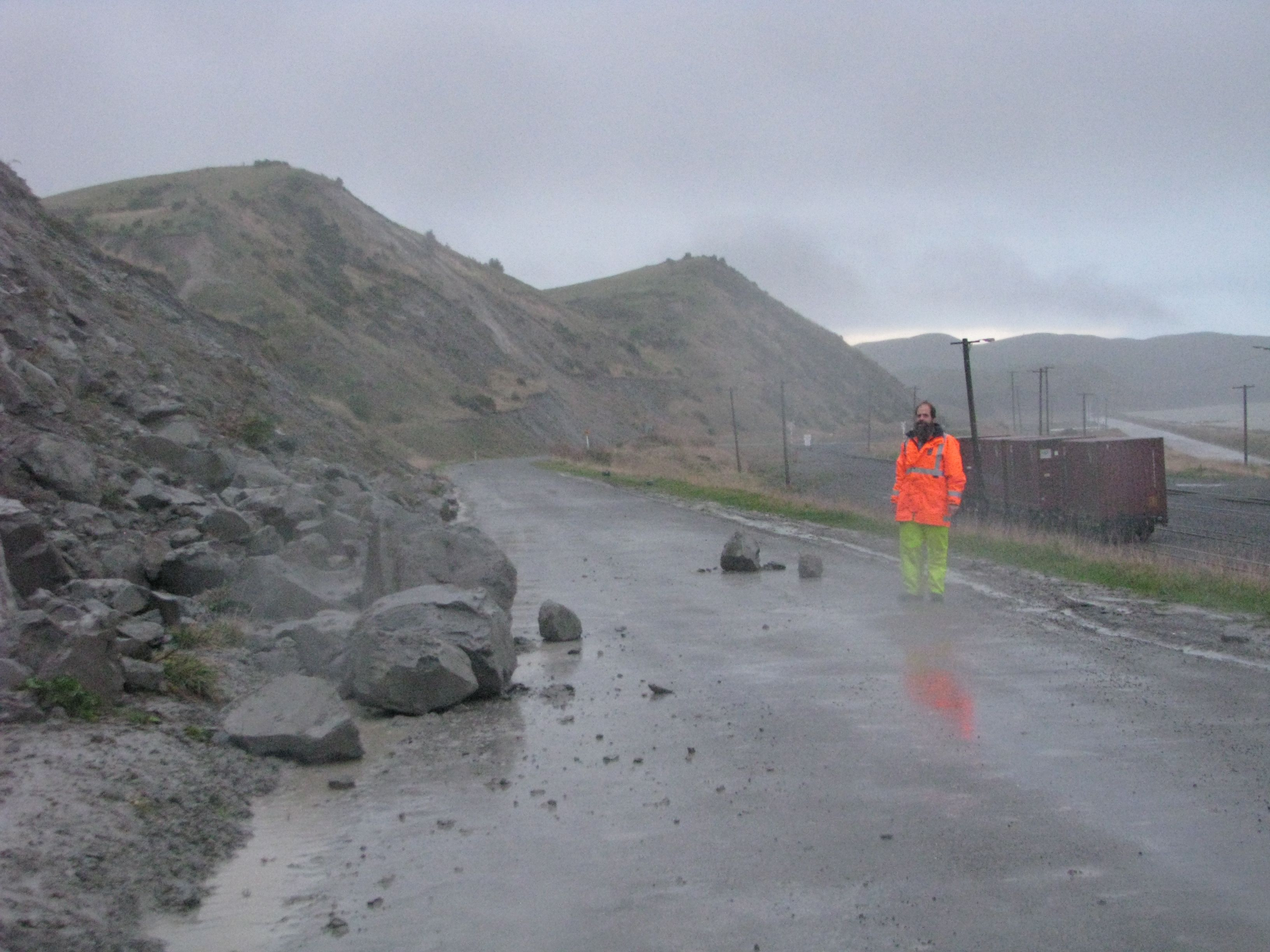
Earthquake triggered rock-fall onto Kaparu Road near Lake Grassmere.
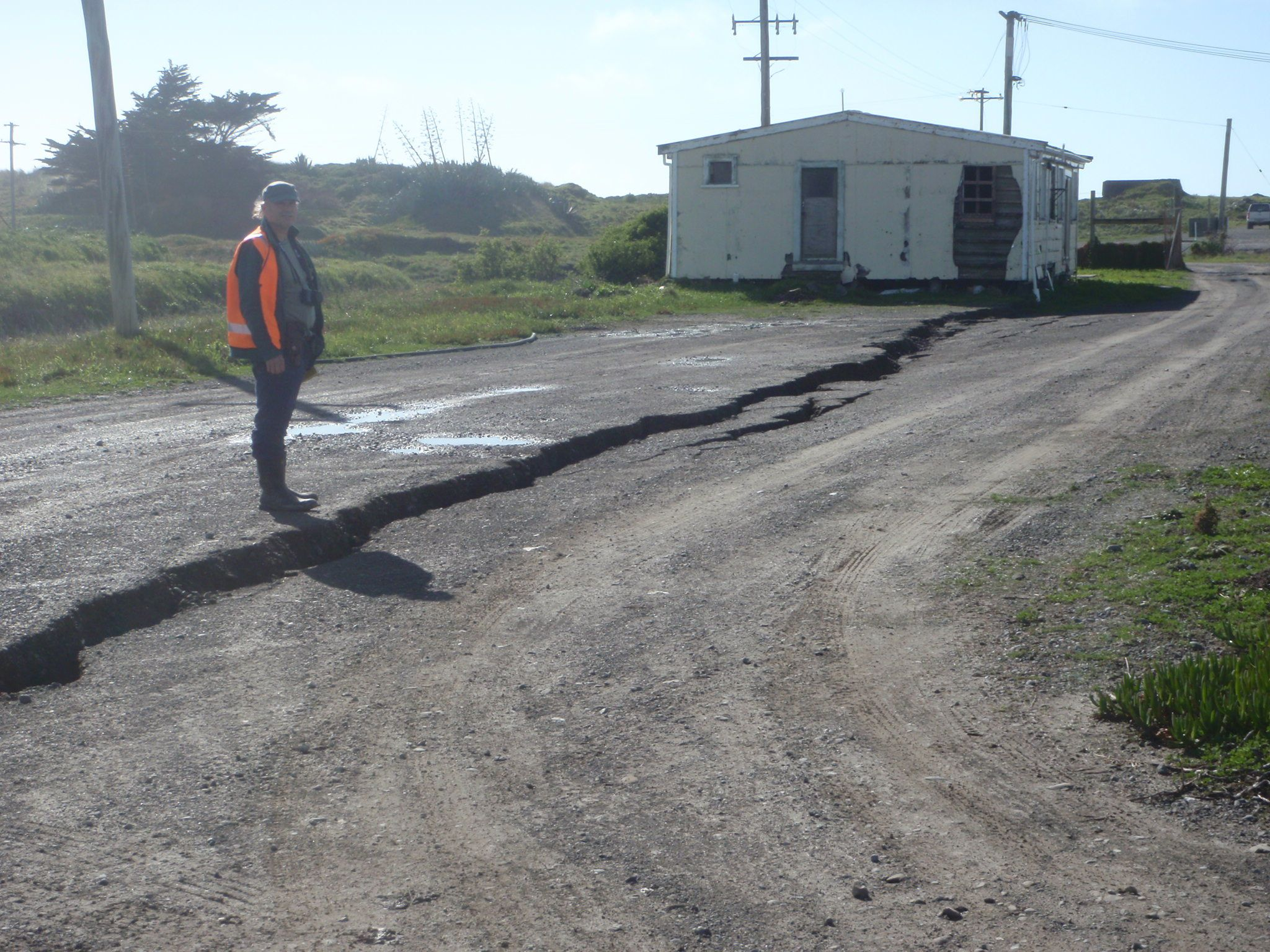
Cracking of service road near Lake Grassmere due to slumping of the road towards nearby channel (out of picture to right).
![Sketches showing the damage to buildings sustained in the 1848 Wellington earthquake. [Park, Robert 1812-1870. Ref #: PUBL-0050-01 Part of: An account of the earthquakes in New Zealand]](https://static.geonet.org.nz/info/images/quakes/historic/2177819/2326664.png)
Sketches showing the damage to buildings sustained in the 1848 Wellington earthquake. [Park, Robert 1812-1870. Ref #: PUBL-0050-01 Part of: An account of the earthquakes in New Zealand]
![The raised platforms at Turakirae head mark old shorelines (visible as pale bands). The first shoreline inland from the present day coast is where the shoreline was in 1855, before the area was uplifted by the Wairarapa earthquake. [Earth Sciences NZ]](https://static.geonet.org.nz/info/images/quakes/historic/2178057/1278068.jpg)
The raised platforms at Turakirae head mark old shorelines (visible as pale bands). The first shoreline inland from the present day coast is where the shoreline was in 1855, before the area was uplifted by the Wairarapa earthquake. [Earth Sciences NZ]
![Landslip caused by earthquake near Wellington, New Zealand. January 1855. [Gold, Charles Emilius 1809-1871. Ref #: B-103-016]](https://static.geonet.org.nz/info/images/quakes/historic/2178057/2326605.jpg)
Landslip caused by earthquake near Wellington, New Zealand. January 1855. [Gold, Charles Emilius 1809-1871. Ref #: B-103-016]
!["This surveyor stands at a fence that crosses the Hope Fault near Glynn Wye Station. The fence, originally straight, has been kinked to the right by the sideways movement of the land in the 1888 earthquake. [Earth Sciences NZ]](https://static.geonet.org.nz/info/images/quakes/historic/2178073/1278067.jpg)
"This surveyor stands at a fence that crosses the Hope Fault near Glynn Wye Station. The fence, originally straight, has been kinked to the right by the sideways movement of the land in the 1888 earthquake. [Earth Sciences NZ]
!["Although most of the movement on the Hope Fault was horizontal, some was vertical, raising the land and creating the scarp surface this man now leans against. [Earth Sciences NZ]](https://static.geonet.org.nz/info/images/quakes/historic/2178073/2326608.jpg)
"Although most of the movement on the Hope Fault was horizontal, some was vertical, raising the land and creating the scarp surface this man now leans against. [Earth Sciences NZ]
![Earthquake-damaged business premises of H. J. Hodgson & Co. in Murchison, 1929. [Jones, Frederick Nelson, 1881-1962. Ref #: 1/2-026346-G Part of: Negatives of the Nelson district (PAColl-3051)]](https://static.geonet.org.nz/info/images/quakes/historic/2178128/2326600.jpg)
Earthquake-damaged business premises of H. J. Hodgson & Co. in Murchison, 1929. [Jones, Frederick Nelson, 1881-1962. Ref #: 1/2-026346-G Part of: Negatives of the Nelson district (PAColl-3051)]
![Cracks in a road in Greymouth, after the 1929 Murchison earthquake, 1929. [Ref #: 1/2-091674-F Part of: West Coast Historical and Mechanical Society: Photographs (PAColl-5376)]](https://static.geonet.org.nz/info/images/quakes/historic/2178128/2326611.jpg)
Cracks in a road in Greymouth, after the 1929 Murchison earthquake, 1929. [Ref #: 1/2-091674-F Part of: West Coast Historical and Mechanical Society: Photographs (PAColl-5376)]
![The force of the earthquake ruptured the ground surface and left these power poles listing heavily. [Earth Sciences NZ]](https://static.geonet.org.nz/info/images/quakes/historic/2178128/2326614.jpg)
The force of the earthquake ruptured the ground surface and left these power poles listing heavily. [Earth Sciences NZ]
![The charred ruins of Emerson Street buildings that were destroyed by the earthquake and subsequent fire. [Christchurch City Libraries, File Reference: CCL PhotoCD 4, IMG0041]](https://static.geonet.org.nz/info/images/quakes/historic/2178228/2326618.jpg)
The charred ruins of Emerson Street buildings that were destroyed by the earthquake and subsequent fire. [Christchurch City Libraries, File Reference: CCL PhotoCD 4, IMG0041]
![Severe surface damage left this road almost impassable after the 1931 earthquake. Note the dislodged power poles in the background. [Earth Sciences NZ]](https://static.geonet.org.nz/info/images/quakes/historic/2178228/1278064.jpg)
Severe surface damage left this road almost impassable after the 1931 earthquake. Note the dislodged power poles in the background. [Earth Sciences NZ]
![Extensive fissuring of the ground surface at Port Ahuriri. [Earth Sciences NZ]](https://static.geonet.org.nz/info/images/quakes/historic/2178228/2326617.jpg)
Extensive fissuring of the ground surface at Port Ahuriri. [Earth Sciences NZ]
![A large section of upper brick wall fell from an old 2-storey building through the roof of the neighbouring near-new single-storey building housing a bookstore. [Earth Sciences NZ]](https://static.geonet.org.nz/info/images/quakes/historic/2839343/2326650.jpg)
A large section of upper brick wall fell from an old 2-storey building through the roof of the neighbouring near-new single-storey building housing a bookstore. [Earth Sciences NZ]
![Displacement on Clintons Road, near the intersection with Telegraph Road, Canterbury. [Earth Sciences NZ]](https://static.geonet.org.nz/info/images/quakes/historic/3366146/2326658.jpg)
Displacement on Clintons Road, near the intersection with Telegraph Road, Canterbury. [Earth Sciences NZ]
![Displaced tree rows off Telegraph Road, near Greendale, Canterbury. [Earth Sciences NZ]](https://static.geonet.org.nz/info/images/quakes/historic/3366146/2326657.jpg)
Displaced tree rows off Telegraph Road, near Greendale, Canterbury. [Earth Sciences NZ]
![Surface fracture approaching a farm shed off Kivers Road, near Burnham, Canterbury. [Earth Sciences NZ]](https://static.geonet.org.nz/info/images/quakes/historic/3366146/2326656.jpg)
Surface fracture approaching a farm shed off Kivers Road, near Burnham, Canterbury. [Earth Sciences NZ]
![Car trapped by liquefaction in Ferrymead, Christchurch. [Earth Sciences NZ]](https://static.geonet.org.nz/info/images/quakes/historic/3468575/2326660.jpg)
Car trapped by liquefaction in Ferrymead, Christchurch. [Earth Sciences NZ]
![Damage to buildings in the central city, Christchurch. [Earth Sciences NZ]](https://static.geonet.org.nz/info/images/quakes/historic/3468575/2326659.jpg)
Damage to buildings in the central city, Christchurch. [Earth Sciences NZ]